Deepwater Horizon Oil Spill Update, May 4th
I've been following the oil spill coverage with some interest for the last few days - waiting to hear what the word is on what the leak rate really is, and whether things are getting any better.
An organization called SkyTruth has posted an image from today, from the NASA AQUA images, which I've altered a bit to bring out the spill area with a bit more contrast.
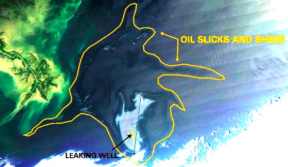
The line I marked on the significant area of the leak is about 50km.
Compared to this image from Apr 29th:
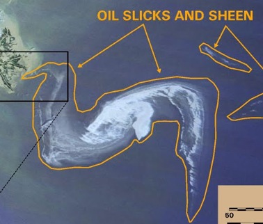
It seems somewhat thicker today than on Apr 29th but not as bad as you'd expect given the 5 days of spillage between then and now.  Maybe some of the mitigation efforts (such as the dispersing chemicals) are working.
The CBC was interviewing some folks from the New Orleans area about this today and one of the people they talked to said they weren't sure yet if this was a disaster or just a mess. Â I thought that was an interesting characterization. Â But I'm guessing, disaster.
News reports talk of hundreds of thousands of feet of booms being set up to try to stop the oil. Â A mayor of a small coastal town mentioned in an interview that they were having to pay for renting the booms themselves, at a cost of $.50/day. Â Hundreds of thousands of feet of booms means hundreds of thousands of dollars a day just for boom rental. Â I can't imagine what the cost of this is going to be.
Meanwhile here's a photo of some fishing vessels preparing to help with burning oil on the surface.